Storms Forecast for San Antonio Area Bring Severe Weather Risk and Uneven Rainfall
Storms are expected to develop in West Texas late Saturday, moving eastward overnight and impacting regions near Del Rio, Rocksprings, and the Hill Country. Forecasters warn that these storms may be strong or severe, bringing the potential for hail, localized street flooding, and gusty winds through Saturday night.
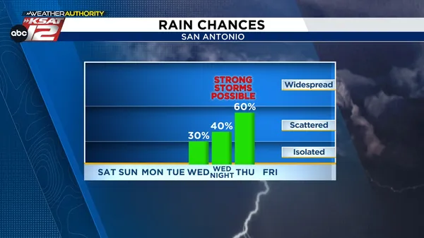
By early Sunday, storms are forecasted to cross the I‑35 Corridor, including San Antonio, with a 40–50% chance of storm activity in the morning hours. Meteorologists indicate that a slight weakening of storms is possible as they approach the city, but the threat of severe weather will persist throughout the day.
Additional storms could redevelop on Sunday afternoon and evening, particularly if cloud cover diminishes and temperatures rise, with the risk of damaging winds, hail, and locally heavy rain continuing. The chance of precipitation remains at around 40% throughout Sunday. Temperatures outside of storm periods are forecasted to be warm and humid, with highs approaching 80 degrees.
Rainfall is expected to be unevenly distributed across the region. The highest precipitation totals are anticipated to occur north and west of San Antonio, especially over the Edwards Plateau and Hill Country. Most areas around San Antonio are likely to receive less than a quarter inch of rain, according to forecasts.
The unsettled weather pattern is predicted to persist into next week, with continued chances for rain in South‑Central Texas from Monday through midweek. Daytime highs are projected to climb to the upper 80s near the beginning of Fiesta celebrations.
Weather authorities advise residents to monitor updates for any changes in the storm outlook and to remain alert for the possibility of severe weather, especially in the overnight and afternoon hours.


COMMENTS (0)
Sign in to join the conversation
LOGIN TO COMMENT