Bomb Cyclone Forecast to Bring More Snow and Dangerous Cold to NYC
Bomb Cyclone Expected to Reach New York City This Weekend
A bomb cyclone winter storm is forecast to move into New York City on Saturday night and remain through Sunday. The system is expected to bring additional snowfall and colder temperatures to the city and surrounding region.
Snowfall and Wind Projections for the New York City Area
The storm could produce up to 3 inches of snow in the New York City area. This snowfall will arrive as the region is still clearing more than a foot of snow that fell on Sunday and Monday during a previous winter storm. AccuWeather meteorologists report that strong winds are expected to accompany the bomb cyclone.
Forecasters indicate that temperatures in New York City are already hovering between approximately 14 and 24 degrees Fahrenheit. With the arrival of the bomb cyclone and its strong winds, wind chills are expected to drop into the single digits and even below zero.
Forecast Assessments from Meteorologists
AccuWeather senior meteorologist Matt Benz stated that Sunday will likely be a blustery day, especially from New York City east and south. He said that snow in the city could lead to slippery roads on Sunday. Benz also indicated that, unless there is a major shift in the storm track to the west, travel conditions in New York City are not expected to be as dangerous as those experienced during Winter Storm Fern last weekend.
More Severe Conditions Expected on Long Island
According to the forecast, areas east of New York City on Long Island are expected to experience worse conditions than the city. As much as 6 inches of snow could fall on Long Island, and white-out blizzard conditions could affect both the north and south forks. The storm system is expected to move out of the area by Sunday night.
Extended Cold and Limited Precipitation Outlook
Meteorologists forecast that temperatures in the region will remain frigid into next week. The freezing point is expected to be exceeded by only one degree next Thursday. Beyond the bomb cyclone, only a few flurries are forecast for the foreseeable future.
Broader East Coast Impacts
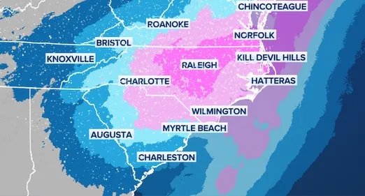
The bomb cyclone is likely to affect the East Coast from South Carolina through Maine. Similar snowfall amounts are projected in several locations. The forecast indicates that Boston could receive between 3 and 6 inches of snow, while Philadelphia and Washington, D.C., may see between 1 and 3 inches. Central regions of Virginia and North Carolina could experience between 6 and 12 inches of snow, according to AccuWeather.
Recent Snowfall Totals and Ongoing Cold
The new storm follows Winter Storm Fern, which recently dropped significant snow across the Northeast. New York City recorded more than a foot of snow on Sunday, Boston recorded about 23 inches, and Philadelphia received just under a foot. Much of that snow remains on the ground days later because temperatures have stayed well below freezing.
In New York City, meteorologists have previously advised that the current cold spell is expected to persist into February. They forecast that temperatures will remain in the teens and 20s and have described the cold as exceptionally dangerous.


COMMENTS (0)
Sign in to join the conversation
LOGIN TO COMMENT